Seeing Water Like Never Before
The Surface Water and Ocean Topography (SWOT) satellite may be one of the most revolutionary Earth-observing missions that you haven’t heard of. With a mission budget of over $1.1 billion, the SWOT satellite (set to launch later this year on a SpaceX Falcon 9 rocket) is the product of an almost 20-year international collaboration between NASA’s Jet Propulsion Laboratory and the French space agency (Centre National D’Etudes Spatiales, CNES), with contributions from the Canadian Space Agency (CSA) and the United Kingdom (UKSA) Space Agency.
Unlike satellites that have come before, SWOT will provide the first global coverage of Earth’s water cycle. For at least three years, SWOT will measure the height of the world’s oceans, rivers, lakes, reservoirs, and wetlands at an unprecedented scale and accuracy. With this new information, we will be able to monitor freshwater resources, track natural hazards, and even forecast climate on a global scale.
Mission Objectives & Lifetime
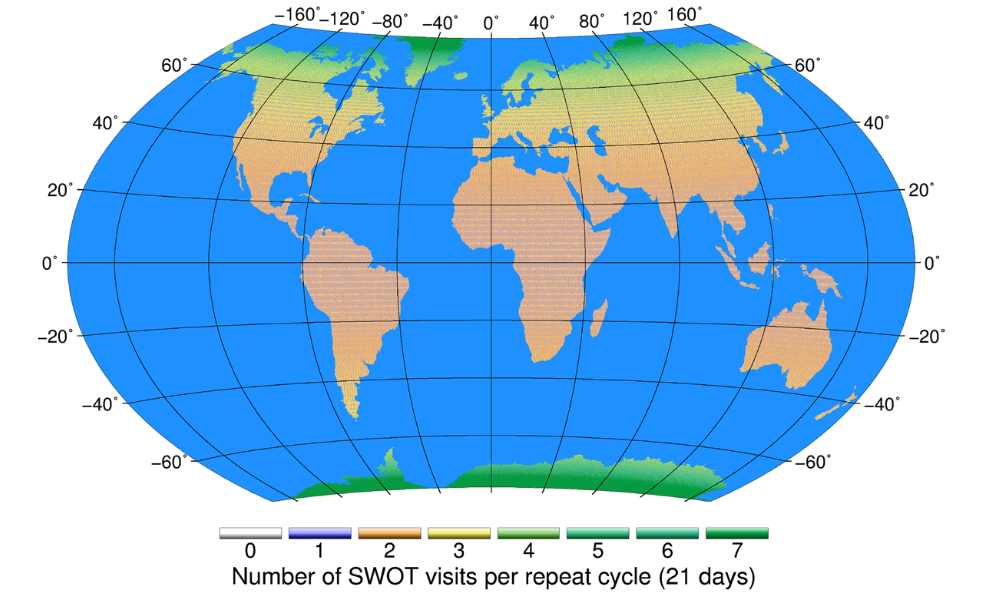
Once operational, SWOT will enter a three-month period where scientists from around the world (including members of UNC’s Global Hydrology Laboratory) will be in the field collecting ground truth data daily at the same time as the satellite observations. Once observations are calibrated and validated using the field data, SWOT will enter its official science phase, collecting data for the entire planet (at least once every 21-days). These observations will allow the global water cycle to be tracked on a monthly, seasonal, and yearly timescale, for all lakes, reservoirs, and wetlands (whose surface area exceeds 250 m x 250 m), all rivers wider than 100 m, along with ocean currents and swirling eddies at scales as small as 20 kilometers.
A few of the official mission objectives are:
- Measure and track how much water is stored within lakes, reservoirs, and wetlands
- Measure and track how river discharge changes over space and time
- Study the dynamics of floodplains and wetlands to monitor flood hazards and ecosystem health
- Provide a better understanding of coastal processes
- Measure circulation, currents, and swirling eddies
- Improve computer models to project future climate-ocean conditions
The water cycle itself is relatively straightforward: condensation, precipitation, collection, and evaporation. However, the processes within the cycle are often much more complex with infiltration to groundwater, transpiration from plants, and ocean circulation. These processes don’t factor in how humans, or a changing climate, alter the circulation of water. With increasing water scarcity and natural hazards around the world, understanding the cycle of water on Earth’s surface is crucial to the longevity of cultures and ecosystems worldwide.